
Category:Maps of the history of Oceania
Temperate regions: Americas · North America · South America · Africa · Europe · Asia · Oceania – Polar regions: – Other regions:
Use the appropriate category for maps showing all or a large part of Oceania. See subcategories for smaller areas:
| If the map shows | Category to use |
|---|---|
| Oceania on a recently created map | Category:Maps of Oceania or its subcategories |
| Oceania on a map created more than 70 years ago | Category:Old maps of Oceania or its subcategories |
| the history of Oceania on a recently created map | Category:Maps of the history of Oceania or its subcategories |
| the history of Oceania on a map created more than 70 years ago | Category:Old maps of the history of Oceania or its subcategories |

Subcategories
This category has the following 11 subcategories, out of 11 total.
!
*
A
E
N
T
W
Media in category "Maps of the history of Oceania"
The following 44 files are in this category, out of 44 total.
-
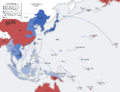
 Second world war asia 1943-1945 map de.png 1,298 × 998; 193 KB
-
 Second world war asia 1943-1945 map pl2.png 1,300 × 1,000; 214 KB
-
 Australia and Oceania Rus.jpg 2,873 × 1,969; 664 KB
-
 Australie-Occidentale française.png 447 × 236; 49 KB
-
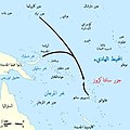 Battle of Santa Cruz map-ar.jpg 800 × 799; 105 KB
-
 Battle of Santa Cruz map-fr.svg 1,345 × 1,343; 146 KB
-
 Cookroutes.png 643 × 430; 113 KB
-
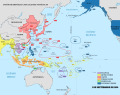
 East Asia and Oceania 1914 german.png 2,008 × 1,546; 463 KB
-
 East Asia and Oceania 1914-de.svg 2,613 × 2,013; 1.15 MB
-
 East Asia and Oceania 1914-en.svg 2,613 × 2,013; 1.15 MB
-
 East Asia and Oceania 1914-fr.svg 2,613 × 2,013; 1.15 MB
-
 East Asia and Oceania 1914-no text.svg 2,613 × 2,013; 1.16 MB
-
 Kleinschmidt-Forschungsaufenthalte-Ozeanien PDF.pdf 1,735 × 495; 3.81 MB
-
 Kleinschmidt-Forschungsaufenthalte-Ozeanien PNG.png 3,472 × 992; 3.26 MB
-
 Kolonialmächte im Pazifikraum, 1939.svg 1,039 × 814; 1.76 MB
-
 Le Maire en Schouten - Reis via Kaap Hoorn naar Indie 1615-1616.png 1,021 × 474; 60 KB
-
 Map of Near and Remote Oceania and location of Efate Island, Vanuatu.tif 2,309 × 1,472; 913 KB
-
 Map of the Malolo Island Group depicting the Battle of Malolo.png 850 × 688; 361 KB
-
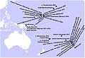
 Miklouho-Maclay's travels - ru.png 1,500 × 1,254; 3.08 MB
-
 Miklouho-Maclay's travels-ru.svg 1,500 × 1,254; 4.6 MB
-
 Oceania politic 1914.png 2,000 × 1,300; 265 KB
-
 Oceania С.jpg 7,864 × 4,883; 1.34 MB
-
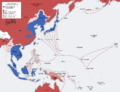
 Pacific Area - Imperial Powers 1939 - Map.svg 1,039 × 814; 4.44 MB
-
 Pacific Area - The Imperial Powers 1939 - Map - ru.svg 1,039 × 814; 4.47 MB
-
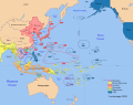 Pacific Area - The Imperial Powers 1939 - Map mk.svg 1,039 × 814; 4.43 MB
-
 Pacific Area - The Imperial Powers 1939 - Map-es.svg 1,039 × 814; 2.89 MB
-
 Pacific Area - The Imperial Powers 1939 - Map-hu.svg 1,039 × 814; 4.47 MB
-
 Pacific Area - The Imperial Powers 1939 - Map-it.svg 1,039 × 814; 2.25 MB
-
 Pacific Area - The Imperial Powers 1939 - Map-zh.svg 1,039 × 814; 4.44 MB
-
 Pacific Area - The Imperial Powers 1939 - Map.jpg 1,202 × 917; 615 KB
-
 Pacific Area - The Imperial Powers 1939 - Map.svg 1,039 × 814; 4.54 MB
-
 Pacific Assembly Programme.jpg 3,637 × 2,727; 2.77 MB
-
 Second world war asia 1937-1942 map blank.svg 1,300 × 1,000; 173 KB
-
 Second world war asia 1937-1942 map pl.png 1,300 × 1,000; 390 KB
-
 Second world war asia 1937-1942 map pl2.png 1,300 × 1,000; 206 KB
-
 Second world war asia 1943-1945 map pl.png 1,300 × 1,000; 398 KB
-
 South Pacific Mandate map in 1930s.PNG 1,751 × 1,071; 895 KB
-
 The Travels of Nathaniel Turner.jpg 1,442 × 1,154; 224 KB
-
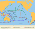 Trajets des navigateurs français en Océanie au XVIIIe - début XIXe siècles.png 3,316 × 2,800; 921 KB
-
 United States Pacific change 1889-05-29.png 2,046 × 1,321; 219 KB
-
 United States Pacific change 1911-07-17.png 2,046 × 1,321; 230 KB
-
 United States Pacific map 1925-03-04 to 1928-04-04.png 2,000 × 1,219; 297 KB
-
 United States Pacific map 1928-04-04 to 1932-12-13.png 2,000 × 1,219; 295 KB
-
_Fr.svg/120px-Wallis%2C_Futuna%2C_Samoa%2C_Tonga%2C_Niue%2C_Fidji_(Polynésie_ancestrale)_Fr.svg.png) Wallis, Futuna, Samoa, Tonga, Niue, Fidji (Polynésie ancestrale) Fr.svg 1,429 × 846; 88 KB
Wallis, Futuna, Samoa, Tonga, Niue, Fidji (Polynésie ancestrale) Fr.svg 1,429 × 846; 88 KB


_Fr.svg)